Caution: Many comments on the markers are incorrect; see descriptions of the
Three Expeditions for proven factual accounts)
COW
FORD
During
the First Florida Expedition, the Georgia Continental Army and Militia advance
guard reached the St. Johns River and fought a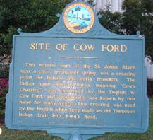 band of pro-British Indians at
the Cow Ford (now Jacksonville.) A graded road with
a ferry crossing at the Cow Ford on the St. Johns River in Colonial times, the
Kings Road bisects Jacksonville today, approximately the route of U.S. Highway
l.
band of pro-British Indians at
the Cow Ford (now Jacksonville.) A graded road with
a ferry crossing at the Cow Ford on the St. Johns River in Colonial times, the
Kings Road bisects Jacksonville today, approximately the route of U.S. Highway
l.
Text: "This narrow part of the St. Johns River, near a clear freshwater spring
was a crossing point for Indians and early travelers. The Indian name Wacca
Pilatka, meaning "Cow's Crossing", was shortened by the English to Cow Ford,
and Jacksonville was known by this name for many years. This crossing was used
by the English when they made an old Timucuan Indian Trail into King's Road."
Florida Board of Parks and Historic Memorials.
Located: On
the grounds of the Duval County Courthouse in downtown Jacksonville, Florida.
FORT MCINTOSH
In
1776, during the First Florida Expedition, the Georgia Continental Army and
Militia rebuilt Fort Howe on the Altamaha and Fort
 McIntosh, named for General
McIntosh. The fort was placed on the banks of the Satilla River, in present
day Brantley County, to protect the cattle on plantations north of the St.
Marys River.
McIntosh, named for General
McIntosh. The fort was placed on the banks of the Satilla River, in present
day Brantley County, to protect the cattle on plantations north of the St.
Marys River.
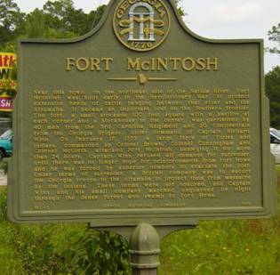
Text: “Near this town, on the northeast side of the Satilla River, Fort
McIntosh was built early in the Revolutionary War, to protect extensive herds
of cattle ranging between that river and the Altamaha. It became an important
post on the southern frontier. The fort, a small stockade 100 feet square with
a bastion at each corner and a blockhouse in the center, was garrisoned by 40
men from the 3rd Carolina Regiment and 20 Continentals from the Georgia
Brigade, under command of Captain Richard Winn.
On February 17, 1777, a large force of Tories and Indians, commanded by
Colonel Brown, Colonel Cunningham and Colonel McGirth, attacked Fort McIntosh,
besieging it for more than 24 hours. Captain Winn refused all demands for
surrender, until there was no longer hope for reinforcements from Fort Howe
and he was forced by superior numbers to evacuate the post. Under terms of
surrender, a British company was to escort the Georgia troops to the Altamaha
to protect them from massacre by the Indians. These terms were not honored,
and Captain Winn and his small company marched unguarded by night through the
dense forest and swamp to Fort Howe.”
GHM 013-3 GEORGIA HISTORICAL COMMISSION 1958
Location: At intersection of U.S. 82 and Ga. 110 in Atkinson, Brantley County,
Georgia.
FORT TONYN
British
Fort Tonyn, named for East Florida Governor Patrick Tonyn, was constructed
in present-day
Nassau County, Florida,
near the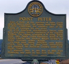 hamlet of
Mill's Ferry,
about
twenty-five miles upstream on the St. Marys River near the King’s Road ferry
crossing. The
Florida Rangers, who were stationed at Fort Tonyn, provided the front line of
defense for British
East Florida,
and also conducted cattle raids in the southern part of the colony of
Georgia.
hamlet of
Mill's Ferry,
about
twenty-five miles upstream on the St. Marys River near the King’s Road ferry
crossing. The
Florida Rangers, who were stationed at Fort Tonyn, provided the front line of
defense for British
East Florida,
and also conducted cattle raids in the southern part of the colony of
Georgia.
POINT PETER Historical Marker Text: “East of here, at the junction of Peter
Creek and St. Mary’s river, the British built Fort Tonyn in 1776; controlling
the southern part of the colony of Georgia for two
years.
In 1778, American
Revolutionary forces, both land and water, forced evacuation of the exposed
position. The English retreated N.W. along North river into Pagan Creek
Plantation, home of the Tories, Charles and Jermyn Wright, brothers of Royal
Governor JamesWright.
On
high land along Alligator (now Borell) creek, they built log and sand
breastworks and repulsed the American Cavalry under Col. Elijah Clark. It
appears that in the War of 1812, Fort Pickering was built on the Fort Tonyn
site.” 020-8 GEORGIA HISTORICAL COMMISSION 1953
Location: Point Peter Rd. near intersection with Osborne in St. Marys, Georgia
KINGS
ROAD
 During
the early 1760’s, the Kings Road was built by the British on an old
Timucuan Indian Trail from St. Augustine to the St.
Marys River, and then connected with the Kings Road in Georgia. This
major north-south route 200 miles long and 16 feet wide, stretched all the way
from Savannah to St. Augustine. In the 19th Century, the road
became known as Post Road.
During
the early 1760’s, the Kings Road was built by the British on an old
Timucuan Indian Trail from St. Augustine to the St.
Marys River, and then connected with the Kings Road in Georgia. This
major north-south route 200 miles long and 16 feet wide, stretched all the way
from Savannah to St. Augustine. In the 19th Century, the road
became known as Post Road.
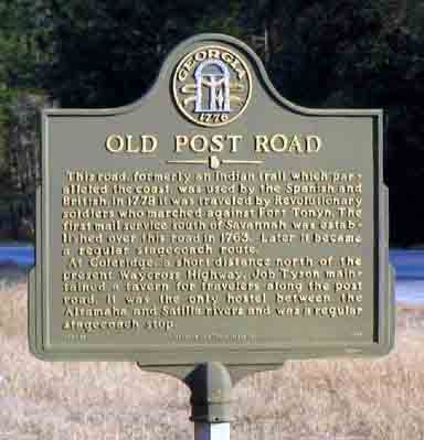
OLD POST ROAD Historical Marker Text: “This
road, formerly an Indian trail which paralleled the coast, was used by the
Spanish and British. In 1778 it was traveled by Revolutionary soldiers who
marched against Fort Tonyn. The first mail service south of Savannah was
established over this road in 1763. Later it became a regular stagecoach
route. At Coleridge, a short distance north of the present Waycross Highway,
Job Tyson maintained a tavern for travelers along the post road. it was the
only hostel between the Altamaha and Satilla rivers and was a regular
stagecoach stop.”
063-4B GEORGIA HISTORIC MARKER 1996
Location:
Ga. 32 and Post Road at Brantley and Glynn County line
AMELIA ISLAND
Continental
Colonel Samuel Elbert landed on the north end of Amelia Island on May 18, and
dispatched
a patrol
to
prevent the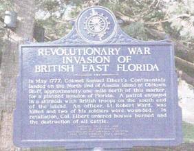 inhabitants from relaying his position to Loyalists on the
mainland. Some Loyalists fired on the Continentals, and in retaliation, Elbert
ordered the burning of every house on Amelia and destruction of livestock. For
six days, the Georgia galleys tried to get through the Amelia Narrows into the
Nassau River to rendezvous with Lt.Colonel John Baker, but with too much draft
and too much weight on board, they could not.
inhabitants from relaying his position to Loyalists on the
mainland. Some Loyalists fired on the Continentals, and in retaliation, Elbert
ordered the burning of every house on Amelia and destruction of livestock. For
six days, the Georgia galleys tried to get through the Amelia Narrows into the
Nassau River to rendezvous with Lt.Colonel John Baker, but with too much draft
and too much weight on board, they could not.
Historical Marker Text: “In May 1777,
Colonel Samuel Elbert’s Continentals landed
on the north end of Amelia Island at Oldtown Bluff, approximately one mile
north of this marker, for a planned invasion of
Florida. A patrol engaged in a skirmish with British troops on the south end
of the island. An officer, Lt. Robert Ward, was killed and two soldiers were
wounded. In retaliation, Colonel Elbert ordered houses burned and the
destruction of all cattle.”
Location: Railroad Depot Plaza in Fernandina Beach
BATTLE OF THOMAS CREEK
In
the spring of 1777, Colonel Samuel Elbert planned a Second Florida Expedition.
He ordered Lt. Colonel John Baker with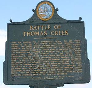 Continental Light Horsemen and mounted
Georgia Militia to proceed overland and rendezvous
on May 12 at Sawpit Bluff near the mouth of the Nassau River. Elbert then embarked his Continentals on vessels to travel through the Inland
Passage to
Sawpit Bluff
at the south end of Amelia Island. Baker arrived at the rendezvous point
at the appointed time;
found that
Elbert had not arrived; and he moved to a better protected position on Thomas
Creek. There they were ambushed by British Regulars, Loyalist Florida Rangers,
and Creek Indians, and Baker's forces were routed with many killed, wounded
and captured.
Continental Light Horsemen and mounted
Georgia Militia to proceed overland and rendezvous
on May 12 at Sawpit Bluff near the mouth of the Nassau River. Elbert then embarked his Continentals on vessels to travel through the Inland
Passage to
Sawpit Bluff
at the south end of Amelia Island. Baker arrived at the rendezvous point
at the appointed time;
found that
Elbert had not arrived; and he moved to a better protected position on Thomas
Creek. There they were ambushed by British Regulars, Loyalist Florida Rangers,
and Creek Indians, and Baker's forces were routed with many killed, wounded
and captured.
Historical Marker Text: “When the American War of Independence began, the
new British colonies of East and West Florida did not seek separation from
England. East Florida remained comparatively free from serious fighting
throughout the course of the Revolutionary War. In the summer of 1777,
however, Americans initiated an invasion aimed at capturing St. Augustine. The
expedition was composed of Continental Army troops and Georgia militia forces
under the command of Lt. Col. Samuel Elbert. Preparations for the defense of
East Florida involved the East Florida Rangers, a force of mounted
provincials, British Regulars, and Indian allies. On May 17, 1777, a portion
of the invading American expedition was attacked by a detachment of British
Regulars under Maj. J.M. Prevost assisted by Rangers under Col. Thomas Brown
and Indians. The battle took place at a site on Thomas Creek south of its
confluence with the Nassau River. After suffering heavy casualties, the
Americans, already discouraged by lack of supplies and the heat, began their
retreat from Florida. Only one more unsuccessful invasion of East Florida
occurred during the remaining years of the American Revolution.” Florida
Society, Children of the American Revolution in cooperation with Florida
Department of State.
Location:
On U. S. Highway 1 where it crosses Thomas Creek south of Callahan.
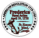
FREDERICA NAVAL ACTION
 During
the preparation for the Third Florida Expedition at Fort Howe, Elbert learned
that four British vessels were sailing in the St. Simons Sound, between St.
Simons and Jekyll Islands. Sailing from Darien, Elbert’s flotilla arrived near
Fort Frederica
on April 18. Colonel Elbert observed the British attack preparations, and at
daybreak on April 19, 1778, he initiated an attack against the British vessels
anchored at the fort.
The British attempted to retaliate, but were out-gunned and
out-maneuvered. As they tried to gain an advantage by moving down river their
ships grounded, were abandoned, and captured by Elbert’s forces.
During
the preparation for the Third Florida Expedition at Fort Howe, Elbert learned
that four British vessels were sailing in the St. Simons Sound, between St.
Simons and Jekyll Islands. Sailing from Darien, Elbert’s flotilla arrived near
Fort Frederica
on April 18. Colonel Elbert observed the British attack preparations, and at
daybreak on April 19, 1778, he initiated an attack against the British vessels
anchored at the fort.
The British attempted to retaliate, but were out-gunned and
out-maneuvered. As they tried to gain an advantage by moving down river their
ships grounded, were abandoned, and captured by Elbert’s forces.
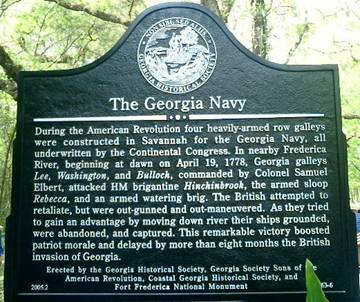
THE GEORGIA NAVY Historical Marker Text:
“During
the American Revolution four heavily-armed row galleys were constructed in
Savannah for the Georgia Navy, all underwritten by the Continental Congress.
In nearby Frederica River, beginning at dawn on April 19, 1778, Georgia
galleys Lee, Washington, and Bulloch, commanded by Colonel Samuel Elbert,
attacked HM brigantine Hinchinbrook, the armed sloop Rebecca, and an armed
watering brig. The British attempted to retaliate, but were out-gunned and
out-maneuvered. As they tried to gain an advantage by moving down river their
ships grounded, were abandoned, and captured. This remarkable victory boosted
patriot morale and delayed by more than eight months the British invasion of
Georgia.”
Erected by the Georgia Historical Society, Georgia Society Sons of the
American Revolution, Coastal Georgia Historical Society, and Fort Frederica
National Monument.
Location: The Georgia Navy Historical Marker which describes the Frederica
Naval Action is located at the entrance to Fort Frederica National Monument on
Frederica Road
BATTLE AT ALLIGATOR CREEK BRIDGE
In May, 1778, on the third attempt to drive the British back toward St.
Augustine, Governor John Houston led the Georgia Militia; Georgia and South
Carolina Continentals were under General Robert Howe; South Carolina Militia
was commanded by Colonel Andrew Williamson; and Georgia Naval vessels were
under the command of Commodore Oliver Bowen. Dissension among the commanders,
heat and illness among the troops caused the invasion to fail in a battle near
Alligator Creek Bridge on June 30, 1778.
The
destruction of Fort Tonyn was one of the principal goals of Gen. Howe’s
Continentals. On June 28, Howe’s 400 Continentals finally began their march to
Fort Tonyn, but their delay crossing the St. Marys had given Brown’s 200
Rangers time to remove their supplies and burn the fort. On June 29, Howe’s
forces “captured” the burned fort and occupied it through mid- July.
Governor
Houstoun was determined to march his 300 Militia on the Kings Road toward St.
Augustine, forcing a confrontation with
Major
Prevost’s 500 Regulars and 200 South Carolina Royal Americans posted fifteen
miles away. They had constructed a redoubt of logs and brush
with a wide moat to defend the Alligator Creek Bridge over that
tributary of the Nassau River.
On
June 30, 1778, General
Screven’s 100 mounted Georgia Militia pursued Brown’s Rangers as they
retreated south from Fort Tonyn toward Alligator Creek. Colonel Elijah Clarke
led 100 mounted Georgia militia on an attack on the weakest British flank, so
Screven could advance on the British front. The British Regulars and Rangers
met Clarke’s forces, Clarke
was shot through his thigh, and barely escaped capture. With the failure of
Clarke’s attack, Screven’s main reserve force did not attack
and many narrowly escaped being trapped before Screven ordered the retreat.
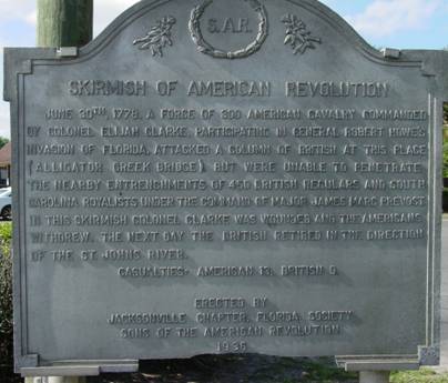
Alligator Creek Historical Marker Text: SKIRMISH OF AMERICAN REVOLUTION-
June 30, 1778, a force of 300 American Cavalry commanded by Colonel Elijah
Clarke, participating in General Robert Howe's invasion of Florida, attacked a
column of British at this place (Alligator Creek Bridge), but were unable to
penetrate the nearby entrenchments of 450 British Regulars and South Carolina
Royalists under the command of Major James Marc Prevost. In this skirmish,
Colonel Clarke was wounded and the Americans withdrew. The next day, the
British retired in the direction of the St. Johns River. Casualties: Americans
13 British 9.” Erected by Jacksonville Chapter, Florida Society Sons of
the American Revolution.
Location: On the east side of U.S. Highway 1 in Callahan in Nassau County,
located approximately 20 miles northwest of Jacksonville.
Prepared by Bill Ramsaur, Marshes of Glynn Chapter, Georgia Society Sons of
the American Revolution, Revised 2/15/2014